 |
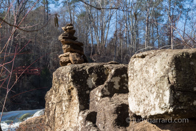
| Rock Sculpture at High Falls |
One of my goals is to visit most, if not all, of Georgia's State Parks. High Falls State Park has been high on my list, and with the recent rains, I thought this may be a good weekend for a visit. I also discovered that Indian Springs State Park was near, so I added that to my list.
I must admit that although I love to hike, I mostly went to see and photograph the falls. Since I had to drive over an hour to get there, and since I was also saving some energy to visit Indian Springs and then the drive home, I didn't walk any of the trails end to end.
With waterfall photography, if you're wanting to get that smooth, silky look to the water, you have to use a tripod. Carrying all of my gear is a workout all by itself!
 |
| The Hydroelectric Plant Ruins at High Falls State Park |
High Falls State Park is separated by High Falls Road with part of the park being on one side and part of it on the other. It's also separated on each side by the water—think of a plus sign. This meant you had to either repark the car each time, or you had to cross the road on foot.
 |
| Trees growing out of the top of the ruins. |
I started out by parking near the mill ruins. I wasn't sure if I could capture anything that would be a little different, but when I noticed the trees growing out of the top, and I knew I hadn't seen any other photos of that, I figured that would be my different photo. You tell me.
Next, I moved my car to the other side of High Falls Road. That parking lot is the closest to the trail that runs next to the north side of the falls. You have to walk across the road, but it isn't too bad. It's only two lanes and there is a designated place to cross.
 |
| View of the High Falls waterfalls closest to the overpass. |
I thoroughly enjoyed shooting the falls. I shot between 1 and 2.5 seconds to vary the smoothness of the water. I also used ND filters ranging from 2 to 8, and I stacked them in a couple of combinations. It was rather sunny, so all three stacked worked best for a 2-second exposure.
 |
| View of the lower area of High Falls. |
Before heading back to shoot the dam, I took a little stroll to see if there was another access point to shoot the falls. There wasn't, but I found a really pretty area where I wished there had been a bench to sit and enjoy the tranquility.
 |
| Beautiful tranquil spot on the Towaliga River. |
When I crossed back to the other side of the road, rather than reparking the car, I walked parallel to High Falls Road to get to the main viewing area for the dam. There is a sidewalk, but at both ends it is a goat path. Honestly, Georgia, can't you do better than that? It's a little scary with cars wizzing by so close.
 |
| High Falls Dam |
Since I was now closer to the trail access for the south side of the falls, I walked back across the road—there is no official place to cross at this end—and photographed from that side, too. Notice how different the sky looks from the start of my visit until the end—about three hours. It never rained, but man, those were some wicked clouds that popped up.
 |
| High Falls Dam and south side of falls. |
On the south side of the falls, because one of the viewing areas on the trail is up higher, you could also see under the overpass all the way to the dam. That made for an interesting shot, I think.
I had a great time at High Falls, and I hope I'll get to go back soon. From what I can determine, there are 60 state parks in Georgia, and I've been to 16. A couple of those were as a child, so they need to be revisited. Next stop: Indian Falls State Park.
Have you been to High Falls State Park?
What's your favorite state park?


No comments:
Post a Comment